Blog
Hiking Cape Flattery Trail

Discover the furthest northwest tip of the contiguous United States with a hike along the Cape Flattery Trail on Washington’s Olympic Peninsula.
Cape Flattery is located on the western side of the tip of the Olympic Peninsula, where the Strait of Juan de Fuca merges with the Pacific. The Cape was so named by Captain James Cook in 1778:”… there appeared to be a small opening which flattered us with the hopes of finding an harbor … On this account I called the point of land to the north of it Cape Flattery.” This history makes Cape Flattery the oldest named area in the state.
This part of the peninsula is the Makah Tribe’s ancestral home and recreation permits are required to park and hike the trails. Recreation permits can be purchased at a variety of locations in Neah Bay, just 15 minutes drive from the trailhead. Once purchased, your recreation permit must be displayed in the window of your vehicle and is good for the calendar year.
Be sure to check out the Makah Museum while you’re in Neah Bay, if you can.
Hiking Cape Flattery Trail
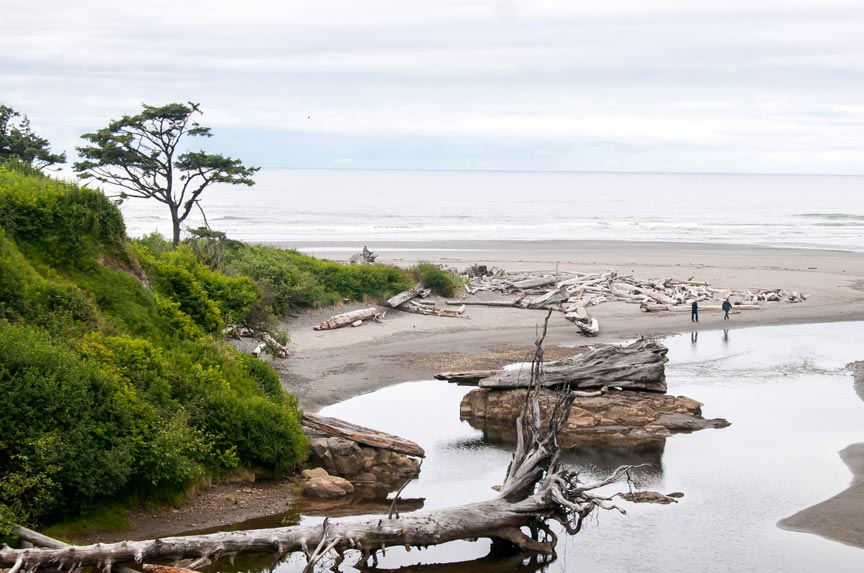
Despite its northern-most position on the Olympic Peninsula, the trail is surprisingly accessible. It’s also quite short – only 1.5 miles, round trip – but what views!
Observation decks, located at various vantages along trail, provide spectacular views of the rugged shore and mercurial Pacific. Wildlife is plentiful, especially birds, but keep an eye out for rarer creatures, too. Sea lions and gray whales are often spotted from Cape Flattery’s observation decks.
The northern-most viewing platform presents stunning views of Tatoosh Island and Cape Flattery Lighthouse, built in 1857. The lighthouse was decommissioned and turned over to the Makah Tribe, who are restoring it, in 2008. The Cape Flattery Light was placed on the U.S. National Register of Historic Places in 2017.
There are picnic tables near the Tatoosh view platform but no trash cans. Please be sure to take out any trash or other items you bring in with you.
The trail itself is a mix of gravel, boardwalk, and rooty tread. The only real “workout” comes at the end when you’re climbing the gentle hill back to the parking lot.
Due to the amount of foot traffic the area sees, it is important to stick to the trail. This will help to preserve the area for others and maybe even future visits of your own.
Getting To Cape Flattery
From Manitou Lodge:
- Take WA-110/La Push Road North to US Hwy 101.
- Follow 101 north for around eleven miles, then turn left on WA-113/Burnt Mountain Road.
- Continue along WA-113 for another ten miles, then continue on to WA-112.
- Stay on WA-112 for around 25 miles, until you reach Neah Bay. Here you’ll want to stop and get your Recreation Permit, if you haven’t already.
- From Neah Bay, follow Backtrack Road west for about 9 miles out to the Cape Flattery Trail trailhead, which has parking and restrooms.
Nearby Attractions
If you can make a day-trip out of your visit to the Neah Bay area, there are many other things to see and do beyond the Cape Flattery Trail. Hobuck Beach, Shi Shi Beach are definitely worth your time – and the Makah Museum deserves another mention, while I’m at it.
Then, once you’ve had enough of the furthest northwest tip of the contiguous United States, head back to your comfie digs at Manitou Lodge!
Recent Posts
- The Olympic Adventure Trail – Get Out On the OAT
- Travel The Washington Whale Trail
- Explore the Olympic Discovery Trail
- Drive the Olympic Peninsula Loop
- Manitou Lodge Camping in Forks Washington
Archives
- February 2021 (2)
- January 2021 (2)
- December 2020 (2)
- November 2020 (2)
- October 2020 (2)
- September 2020 (2)
- August 2020 (2)
- July 2020 (2)
- June 2020 (2)
- May 2020 (1)
- April 2020 (1)
- March 2020 (2)
- February 2020 (2)
- January 2020 (2)
- December 2019 (2)
- November 2019 (2)
- October 2019 (2)
- September 2019 (2)
- August 2019 (2)
- July 2019 (2)
- June 2019 (2)
- May 2019 (2)
- April 2019 (2)
- February 2017 (2)
- July 2015 (1)
- September 2014 (1)
- May 2014 (1)
- September 2013 (1)
- July 2013 (1)
- May 2013 (2)
- September 2012 (2)
Categories
- Attractions (14)
- Forks Washington (5)
- Manitou Lodge Bed and Breakfast (17)
- Olympic National Park (13)
- Olympic Peninsula (4)
- Tourism (2)
- Twilight (2)
- Weather (1)